The Tuscan countryside’s most beautiful views
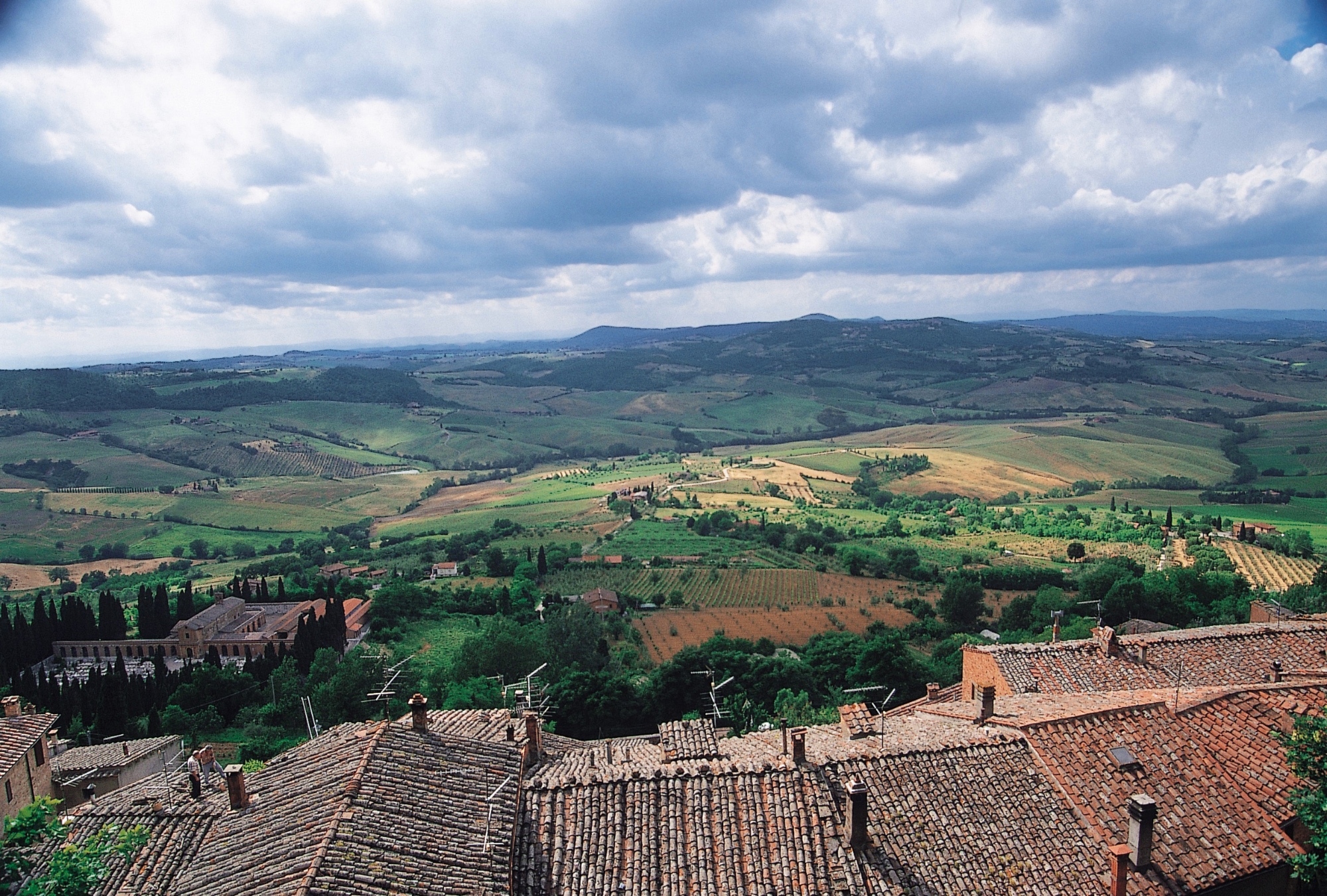
One of the best ways of discovering this high-vocation wine-producing area, situated to the south-east of Siena, is by hiking. Montepulciano and Chianciano Terme represent without doubt an ideal starting point to discover the aromas and flavours of the Valdichiana, along with its natural, cultural and historical attractions.
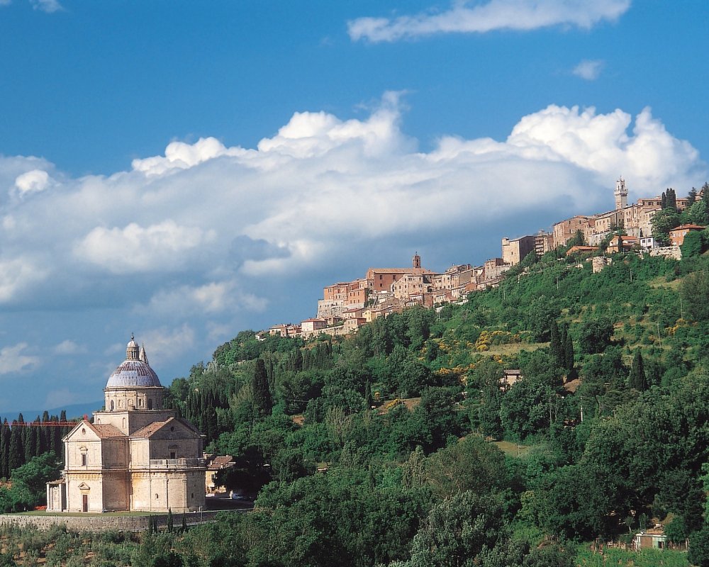
Montepulciano, a village renowned for the quality of its wines, is an excellent link for the high ground of the valleys of Orcia, Ombrone, Mount Amiata and the Cetona. In fact, from the Palazzo Municipale’s tower, in the east you catch sight of the healing hydromineral springs of Chianciano Terme and the small lakes of Montepulciano and Chiusi, while towards the north-west you admire the belt of 14th-century walls of Buonconvento, the monumental Fortress of Montalcino, the solitary abbey of Mount Oliveto Maggiore and Pienza. After admiring the rolling white clay hills, we descend from the tower to visit Montepulciano’s works of art, considered by many the “pearl of the Renaissance”.
The splendid town of Chianciano Terme rises in the east, with its springs once appreciated by the Etruscans and Romans. In the famous thermal centre, rich with healing waters, the brilliant director Federico Fellini set “8½”, while Pirandello’s “Novelle for a year” first took shape here.
Outdoors, there are three unmissable protected areas: the Pietraporciana Nature Reserve, in the district of Chianciano and Sarteano, that at 800m of altitude guards a beech grove over a century old; the Lucciola Bella Nature Reserve, near Pienza, where the Pliocene hills give the landscape a rugged but evocative appearance; and the Montepulciano Nature Reserve, where in the namesake lake – like the one in Chiusi –many birds, both migratory and sedentary, live, which provide joy to those practicing wildlife photography and birdwatching through lenses and telescopes.
At dawn, the steam dissolves and the faint rays of sunlight shine through little by little onto a double row of cypress trees which, outlining the ancient farm road, zigzag up towards the hill’s summit. Here and there, like cliffs in a sea of grain, emerge the biancane, clay hills typical of the Lucciola Bella Nature Reserve, a couple metres high and surrounded by the smell of brooms. Even the calanchi wastelands are the result of a rapid erosion of the clayey land which, like the biancane, were forgone in favour of intense agriculture that has lead the fields to be tinted in June with flaming sunflowers. A different landscape compared to the one crossed by travellers who, urged by strong spiritual motivations, head towards Rome, the centre of Christianity, to pay homage to St Peter’s tomb. The pilgrims stopped at the Hospital of la Scala in Siena, near the town of La Foce, intersected by a branch of the via Francigena.
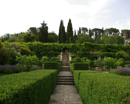
Before taking on the circular hiking trail, make sure to visit the splendid Italian garden of the Marquis Antonio and Iris Origo, built between 1924 and 1939 and based on the designs of the English architect Cecil Pinsent (visits can be arranged on weekdays with pre-booking). The view revealed from the formal lower garden is unparalleled: on the right, the “Vallerese Road”stands out, artificially symmetrical, while on the horizon you catch sight of the sunny Val d’Orcia.
At dawn, the steam dissolves and the faint rays of sunlight shine through little by little onto a double row of cypress trees which, outlining the ancient farm road, zigzag up towards the hill’s summit. Here and there, like cliffs in a sea of grain, emerge the biancane, clay hills typical of the Lucciola Bella Nature Reserve, a couple metres high and surrounded by the smell of brooms. Even the calanchi wastelands are the result of a rapid erosion of the clayey land which, like the biancane, were forgone in favour of intense agriculture that has lead the fields to be tinted in June with flaming sunflowers. A different landscape compared to the one crossed by travellers who, urged by strong spiritual motivations, head towards Rome, the centre of Christianity, to pay homage to St Peter’s tomb. The pilgrims stopped at the Hospital of la Scala in Siena, near the town of La Foce, intersected by a branch of the via Francigena.
Before taking on the circular hiking trail, make sure to visit the splendid Italian garden of the Marquis Antonio and Iris Origo, built between 1924 and 1939 and based on the designs of the English architect Cecil Pinsent (visits can be arranged on weekdays with pre-booking). The view revealed from the formal lower garden is unparalleled: on the right, the “Vallerese Road”stands out, artificially symmetrical, while on the horizon you catch sight of the sunny Val d’Orcia.
The panoramic viewpoint displays the stretch of hills of the Val d’Orcia bordered by the highest summit in the area, Mount Amiata. From the car park of the town of Villa La Foce (555m), follow the dirt track that reaches the small cemetery enveloped by the forest and its calm. Beyond the centuries-old oak trees, proceed towards the Podere Chiarentana (520m), to then conquer the Sarteano slope. After 3km, take the deviation towards the agritourism Il Podere, ascending in the direction of the Tre Case and Santa Maria farms. After an uninterrupted series of ups and downs, you will arrive in a village frozen in time, Castiglioncello sul Trinoro (770 m), one of the most appreciated panoramic viewpoints of the Val d’Orcia, especially at sunset. In this cluster of houses hanging on top of the hill, you can visit the Romanesque Church of Sant’Andrea, a 14th-century gate and the Palazzo Municipale.
The panoramic viewpoint displays the stretch of hills of the Val d’Orcia bordered by the highest summit in the area, Mount Amiata. From the car park of the town of Villa La Foce (555m), follow the dirt track that reaches the small cemetery enveloped by the forest and its calm. Beyond the centuries-old oak trees, proceed towards the Podere Chiarentana (520m), to then conquer the Sarteano slope. After 3km, take the deviation towards the agritourism Il Podere, ascending in the direction of the Tre Case and Santa Maria farms. After an uninterrupted series of ups and downs, you will arrive in a village frozen in time, Castiglioncello sul Trinoro (770 m), one of the most appreciated panoramic viewpoints of the Val d’Orcia, especially at sunset. In this cluster of houses hanging on top of the hill, you can visit the Romanesque Church of Sant’Andrea, a 14th-century gate and the Palazzo Municipale.
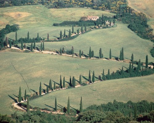
After 7.7 km, slightly beyond Castiglioncello sul Trinoro, a cart road leads onto the left towards the equipped area of Le Crocette (where the Nature Trail begins that crosses an unusual beech grove of low altitude). Beyond the Podere Pietraporciana (847 m), where the reserve’s Visitor Centre, the Educational Workshop and the trekking refuge are located, the northern slope of Chianciano peaks out again and in the distance, its namesake lake emerges. At 11 km you’ll come across the “Bello sguardo” picnic area and in particular, the beautiful beech grove in the Pietroporciana Nature Reserve, which belonged to the vast “La Foce” estate, owned by the Marquis of Origo. Three km remain before returning to the town of “La Foce”, through a forest of pines and holm oaks, and to throw a final glance towards one of the most celebrated and photographed cypress avenues in Tuscany, which descends from the opposite hill, folding on itself at every 180 degree turn.
After 7.7 km, slightly beyond Castiglioncello sul Trinoro, a cart road leads onto the left towards the equipped area of Le Crocette (where the Nature Trail begins that crosses an unusual beech grove of low altitude). Beyond the Podere Pietraporciana (847 m), where the reserve’s Visitor Centre, the Educational Workshop and the trekking refuge are located, the northern slope of Chianciano peaks out again and in the distance, its namesake lake emerges. At 11 km you’ll come across the “Bello sguardo” picnic area and in particular, the beautiful beech grove in the Pietroporciana Nature Reserve, which belonged to the vast “La Foce” estate, owned by the Marquis of Origo. Three km remain before returning to the town of “La Foce”, through a forest of pines and holm oaks, and to throw a final glance towards one of the most celebrated and photographed cypress avenues in Tuscany, which descends from the opposite hill, folding on itself at every 180 degree turn.